

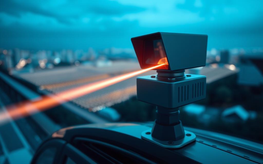
Light Detection and Ranging, or LiDAR, is a new way to map our environment. It uses laser pulses to measure distances very accurately. This is a key part of remote sensing.
The system works by sending out light signals and then measuring how long they take to return. This tells us how far away things are. It creates detailed 3D pictures of what’s around us.
LiDAR is used in many ways today. It helps self-driving cars navigate and archaeologists find new sites. Its wide range of uses makes it very important in many fields.
LiDAR can see through plants and spot small details. This opens up new ways to plan cities and preserve history. It’s changing how we see and interact with our world.
Understanding LiDAR Technology
LiDAR technology is a game-changer in how we see and interact with our surroundings. It uses light detection and ranging to create detailed digital maps of spaces.
How LiDAR Works
LiDAR is a high-tech device that measures distances with great accuracy. It starts by sending out short laser pulses towards objects or surfaces.
These pulses travel fast until they hit something. Then, they bounce back to the sensor.
The time it takes for the pulse to return is measured. This time is used to calculate the distance, thanks to the speed of light.
Related Posts:
- The Latest Technology Trends Shaping Our Future

- What Is Polymer Technology The Science of Plastics…

- What Is EHR Technology Electronic Health Records Explained

- How We Benefit From Technology Advancements in Daily Life

- How Technology Has Transformed Life for the Disabled

- An Example of Manufacturing Technology 3D Printing…

This data creates detailed 3D maps. These maps are so precise, they can show environments down to millimeter detail. LiDAR is essential in many fields because of this.
Types of LiDAR Systems
There are many types of LiDAR systems, each for different uses. Knowing about these helps choose the right one for a job.
Mechanical LiDAR systems use spinning mirrors to scan wide areas. They’re good for covering a lot of ground but need some upkeep.
Solid-State LiDAR is a big step up with no moving parts. It’s reliable and durable, perfect for autonomous driving where consistency is key.
FMCW LiDAR uses continuous laser waves to measure distance and speed. It’s unique because it can track velocity by looking at frequency changes.
Flash LiDAR sends out lots of pulses at once for high-resolution images. It’s great for quick scene captures.
Hybrid LiDAR systems mix different tech for the best results. They’re made to meet specific needs.
Each type of LiDAR has its own strengths. They’re used in everything from finding ancient ruins to helping self-driving cars. As they keep getting better, they’ll help us map and detect objects even more accurately.
What Is LiDAR Technology Used For in Autonomous Vehicles
LiDAR systems are like digital eyes for self-driving cars. They help vehicles see their surroundings with great detail. This technology is key for safe driving in busy cities.
Navigation and Obstacle Detection
LiDAR makes detailed 3D maps of the area around a car. It sends out laser pulses that bounce back, telling the car how far away things are. This happens very fast, creating a detailed picture of what’s around.
It’s great at spotting obstacles, like cars and people. LiDAR knows where everything is and how it’s moving. This helps self-driving cars stay safe and make smart choices.
LiDAR also checks the road and traffic lights. It works well in all kinds of light. This is better than old camera systems.

Real-World Examples: Tesla and Waymo
Big car companies use LiDAR in different ways. Waymo, Google’s car project, uses LiDAR a lot. Their cars have special LiDAR sensors for full coverage.
Tesla started with cameras, but might switch to LiDAR. They’ve bought LiDAR patents, showing they might change their mind. This could make their cars better at driving.
Both Tesla and Waymo know LiDAR is key for better driving. They keep making LiDAR better. This helps us get closer to cars that can drive themselves safely.
LiDAR in Environmental and Agricultural Applications
LiDAR technology is not just for cars. It’s also key in saving our environment and making farming better. It helps us understand ecosystems and grow crops more efficiently.
Forest Management and Carbon Monitoring
LiDAR systems are great for watching over big areas of land. Forest managers use them to map out land and check how green it is.
This info is vital for tracking carbon. It lets scientists know how much carbon forests can hold. This helps us fight climate change and protect forests.
In the sky, LiDAR helps us study the air. It looks at clouds and helps us predict the weather. This makes our weather forecasts more accurate.
Precision Agriculture and Crop Health
Farming gets a big boost from LiDAR. Farmers use it to see their land in detail and track how crops grow.
This tech is at the heart of modern farming. It helps farmers decide when to use fertiliser, water, and more. It also helps predict how much they’ll harvest.
A study in the Journal of Agricultural Science shows LiDAR’s benefits. It cuts down on waste and boosts farm productivity.
LiDAR lets farmers make smart choices. It helps them grow more food while being kinder to the planet. Using LiDAR with other tech is the future of farming.
Urban Planning and Infrastructure Development
LiDAR technology changes how cities plan and keep their buildings in good shape. Urban planners and engineers use these systems to get detailed data. This data is key for modern city planning.
3D Mapping and Smart Cities
Modern city planning needs accurate 3D models of cities. LiDAR makes these models by sending out laser pulses and measuring how long they take to come back. This gives exact models of buildings, roads, and land.
These detailed 3D models are the core of smart cities plans. They help plan city growth, check sunlight, and improve traffic. Cities use them for zoning, emergency plans, and managing utilities.

LiDAR lets planners test new projects virtually before building them. Architects and engineers can see how new buildings will affect views, wind, and traffic. This helps avoid expensive mistakes and makes cities better.
Monitoring Infrastructure Health
LiDAR is key for infrastructure monitoring and upkeep. It finds small changes in bridges, tunnels, and buildings that might show problems. It’s accurate to millimeters without stopping daily work.
Transport departments get a lot from this. They watch over railways, track land sinking, and check bridge changes. This helps them focus on what needs fixing and use resources well.
LiDAR also helps protect old buildings and historical sites. It takes precise measurements and spots where things are getting worse. This helps fix things and keep cultural treasures safe for the future.
LiDAR is great for checking hard-to-reach places. Surveyors can look at dam walls, towers, and coastlines without danger. This way, they keep people safe and make things last longer.
LiDAR in Archaeology and Cultural Heritage
LiDAR technology has changed how we study and protect ancient cultures. It gives archaeologists and preservationists new ways to explore and document our shared past.
Uncovering Hidden Historical Sites
Aerial LiDAR surveys have changed how we find ancient sites, especially in dense forests. They can see through thick vegetation, revealing structures and landscapes we can’t see.
Archaeologists have mapped ancient transportation networks hidden under forests. They’ve found:
- Complete settlement patterns of lost civilisations
- Ancient road systems and trade routes
- Previously unknown ceremonial sites
- Agricultural terraces and water management systems
The technology offers detailed views of sites, helping researchers study without damaging them.
Preserving Ancient Structures
LiDAR helps protect ancient sites too. It creates highly detailed 3D models of structures, which are crucial for preserving our cultural heritage.
These models help preservationists:
- Watch how structures change over time
- Plan exact restoration projects
- Make virtual experiences for education
- Document sites at risk from threats
“LiDAR has fundamentally changed our ability to document and preserve vulnerable heritage sites for future generations.”
LiDAR is especially useful for sites facing threats from climate change, urban growth, or disasters. It creates digital records that keep the details of structures safe, even if they physically deteriorate.
| Application | Benefit | Example Use Case |
|---|---|---|
| Site Discovery | Non-invasive exploration | Mapping Mayan cities in Guatemala |
| Structural Documentation | Millimetre-accurate recording | Preserving Roman ruins in Britain |
| Monitoring Change | Time-series analysis | Tracking erosion at coastal sites |
| Public Engagement | Virtual access creation | Digital tours of inaccessible ruins |
This technology is changing how we learn about history and protect our cultural treasures. It shows how new technology can help preserve our past in amazing ways.
Conclusion
LiDAR technology has shown its worth in many areas, like helping self-driving cars and changing how we find old ruins. It’s a key tool in today’s tech world.
It’s great for watching over the environment and helping farmers grow crops better. City planners use it to make detailed 3D maps of cities and keep buildings safe.
LiDAR has also changed how we study old cultures. It lets experts look at historical sites without touching them. This keeps old treasures safe for the future.
LiDAR started as a special tool but now it’s easy for many to use. It’s leading to new discoveries in science, business, and saving old things for us to learn from. It’s changing how we see and understand our world.
